

SOFT-SEDIMENT DEFORMATION AND FLUID ESCAPE FEATURES ON UPTURNED SALT-RELATED DIAPIR FLANKS

Geo Logica in collaboration with clastic sedimentation expert Deise Silveira from the Basin Analysis Research Lab (LABAP) at Federal University of Paraná (Brazil) is studying soft-sediment deformation and fluid escape features on the flanks of the Santa Cruz Diapir (Portugal).
Halokinesis is a process known to promote localised deformation of the sedimentary overburden deposited over and adjacent to salt structures (e.g., pillows, walls, diapirs).
In clastic settings where sediment consolidation rates are typically slow, bedding rotation induced by rapid diapir rise often involves soft-sediment deformation (SSD) and sediment rearrangement during flap development. Consequently, features such as slumps and deformation bands (e.g., granulation seams) are commonly observed, with increasing frequency near the salt diapir.
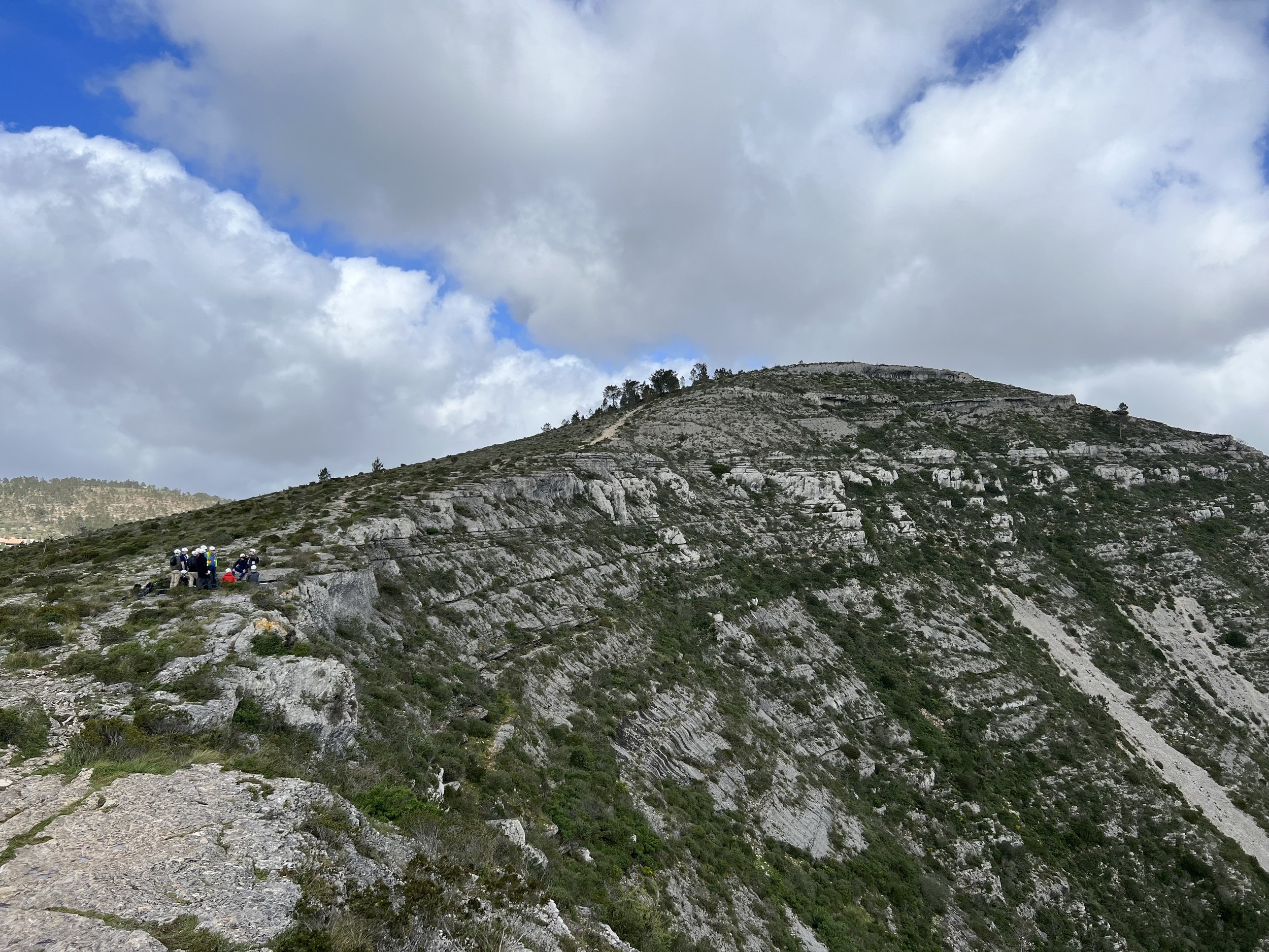
On the western flank of the Santa Cruz Diapir in the Lusitanian Basin (Portugal), Kimmeridgian-age deltaic fan units exhibit a steep upturned flap geometry. Along this flank, in addition to granulation seams and slumps, several SSD and fluid escape features, such as mega-scale convoluted bedding, and certain sand injectites cut through and intrude the sedimentary sequence. These structures are unevenly distributed along the flank.
Detailed sedimentological and structural fieldwork, complemented by UVA and LiDAR imagery interpretation, is being carried out on the western flank of the Santa Cruz Diapir to investigate the distribution and interrelationship of these structures and understand their origin and triggering mechanisms.
The fluid escape features can alter the permeability and connectivity of the reservoir, influence fluid migration, and affect the understanding of hydrocarbon distribution and storage, while playing a significant role in influencing stratigraphic and structural traps. The findings of this study highlight the importance of investigating and analysing these structures to improve the prediction of reservoir performance and hydrocarbon recovery strategies when modelling reservoirs and seals adjacent to salt diapirs.
These and other features associated with halokinesis are explained in our salt tectonics training course that will take place in October 2025. For more info about this course please visit our GeoTraining page: https://www.geologica.xyz/salt-tig-geo-logica-field-trip-i2
Understanding the riddles of energy and CO2 geostorage in and around salt structures from field examples in Portugal

The ongoing energy transition process brought back the importance of salt structures for underground storage of other gases such as hydrogen, carbon dioxide, compressed air, as well as for geothermal energy projects. As usual, new applications bring new concepts, new challenges and new players into the geostorage arena. Nonetheless, new players are often not fully familiarised with the geotechnicalities involved in these projects, and consequently are unaware of the problematics associated.
This project reviews main geological concepts, uncertainties and potential geohazards that need to be considered when planning a geostorage facility inside or adjacent to salt structures. It presents real examples from outcrops, mines and quarries in Portugal combined with seismic and well data. Although Portugal is not an hydrocarbon producer, the country produced asphalt and bitumen from the flank of a salt diapir in the XIX century and for the past two decades has been storing gas in underground storage facilities inside a salt diapir. Adding to outcropping salt structures with world class exposures, it makes the country an ideal field laboratory to understand the variability and complexity of salt structures.
The goal is to provide geoscientists and engineers involved in geostorage projects with real field examples of the main geological technicalities and issues behind underground storage in salt structures, in order to optimize projects and reduce associated risks, from project area screening to project completion as well as during the exploitation of geostorage infrastructures.
Related links: https://www.researchgate.net/publication/385302758_Understanding_the_riddles_of_energy_and_CO2_geostorage_in_and_around_salt_structures_from_field_examples_in_Portugal
Structural Aspects of Magmatic Rocks: Comparison between outcrop and seismic data from the central Western Iberian Margin (WIM), POrtugal.

The aim of this project is to highlight the implications of magmatism in the regional and local structural framework for hydrocarbon maturation, reservoir properties distribution, trap creation and/or destruction, as well as to emphasise potential consequences for the generation of natural hydrogen accumulation and CO2 sequestration and mineralization via basalt carbonation. This study uses examples from post-rift magmatic bodies interpreted from high resolution broadband seismic data from offshore Portugal (central West Iberian Margin), to compare with the onshore sector where similar structures of the same age outcrop (Late Cretaceous (94-69 Ma).
The project was developed in conjunction with Prof. João Mata from Instituto Dom Luiz in Portugal, Tiago Cunha and Marianne Nuzzo from Integrated Geochemical Interpretation (I.G.I.) from the UK and Ricardo Pereira from GeoBioTec, also from Portugal.
Related links: https://imageevent.aapg.org/portals/26/abstracts/2024/4100907.pdf
Carbonate depositional systems and interaction with salt diapirs in central Portugal.
-
https://ciencias.ulisboa.pt/pt/noticia/25-05-2023/excursao-geologica-de-campo-na-bacia-lusitanica
During its preparation, became clearer that several outcrops in the Lusitanian Basin present excellent examples of the interplay between carbonate depositional systems and salt structures. The work developed resulted in Geo Logica’s new field course that highlights the implications of halokinesis on carbonate facies distribution, reservoir properties and source rock distribution as well as trap geometry and seal properties.
This 4-day field course in central Portugal entitled “Carbonates & salt structures” is available at request for companies, institutions and groups.
Related Links: https://www.geologica.xyz/geotraining
Geo Schools Network project “Who Supports Your School?”

-
This Project intends to create a network of Geo-Schools, relaunching the pedagogical activity “Rocha da Região” of Rocha Amiga Program created by Professor Mario Cachão (Faculty of Sciences of University of Lisbon). Initially proposed as part of the celebrations of the International Year of Planet Earth (AIPT-UNESCO) 2008, the Rocha Amiga Program is primarily aimed at key stage 3 to 5 schools in Portugal, with the aim of:
Raise teachers and students awareness of their geological surroundings;
Promote an activity that will allow schools acquire and have a better understanding of Portuguese rocks;
To enrich pedagogically and scientifically the schools rock collections, through geological and environmental reports available online and made from the rocks collected by each school that subscribes this program.
Every year universities are requested by many school teachers to provide geological teaching materials. This happens mainly because there are still a large number of schools across the country that, either do not have an adequate rock collection, or do not have the appropriate rock samples to cover the lectured geological subjects.
Moreover, many school rock collections are not properly classified or do not show any indication of origin. Therefore have low pedagogical value, ending up only being used sporadically in simple identification exercises, without the integration in their geological context geological and/or without extracting all its full potential.
Additionally, many didactic rock collections available in the market for teaching purposes (many of which are acquired by the teachers themselves) are often too small for proper observation and/or have low pedagogical value.
Rocha Amiga and Geo Logica aim to help change this reality, creating a network of Geo-Schools to:
Discover the geological setting where a school is located;
Create or improve the schools didactic rock collections with proper hand samples, through the exchange of rock specimens between schools. This will enable them to be equipped with basic rock collections made up with appropriate specimens from the Geology of Portugal, duly framed, both geographically and geologically.
This initiative aims to raise students and teachers awareness, together with their communities, to the role of Geosciences in modern society, to the omnipresence and importance of rocks in the daily life of citizens, providing support and essential materials for their lives and well-being, from shelter, water, soils for plants and animals, industrial and technological applications, all while promoting the sustainable development of Society.
(Work In Progress)
The History and GeoHIstory behind the old traditional lime Kiln industry from Gândara region, Portugal

-
From the late 40’s until the 80’s there were many communities in Portugal that made their living by producing lime pigments from limestones. In fact there are still a few traditional lime kilns operating in Portugal.
Lime is a calcium oxide made from limestone that is considered a natural and efficient building material (used as cement), a pigment used to paint houses, a substance used to adjust soils acidity and an chemical agent used to treat water.
In Gândara Region, particularly between Coimbra and Montemor-o-Velho (Central Portugal) there were many families that were raised, sustained and even educated with the profit made from the hard labor of extracting and producing lime.
Generally known as “Pedra de Ançã”, the rocks outcropping around Póvoa da Lomba, Andorinha, Zambujal, Fornos and Ançã have been used since ancient times for carving, sculpturing and ornamenting castles, palaces, monasteries, churches and houses throughout in Portugal, and even Spain. Nonetheless, at the end of World War II the demand for this material was immense which lead to the development of many small family-owned lime kilns in the region.
Geo Logica is looking at the characteristics of the Middle Jurassic marine sediments, deposited approximately between 170 and 160 Millions ago, on what was once a shallow warm sea, to understand why these limestone rocks made Gândara region the main centre of lime production Portugal.
Work in Progress.
devonian CArbonates Sampling, VEndas NOvas, Portugal (2017-2021)

-
Detailed sampling of geological units is crucial to date rocks and understand past geographical environments in which these were formed.
Although the majority of rock formation known have been already sampled, analysed and dated, there is still plenty of sampling gaps and consequently work that needs to be developed, particularly in remote and/or more inaccessible areas. Often difficult to access rock exposures bare key information that allows to correlate major geological units previously uncorrelated. This was the moto for the cooperation between researchers in this project.
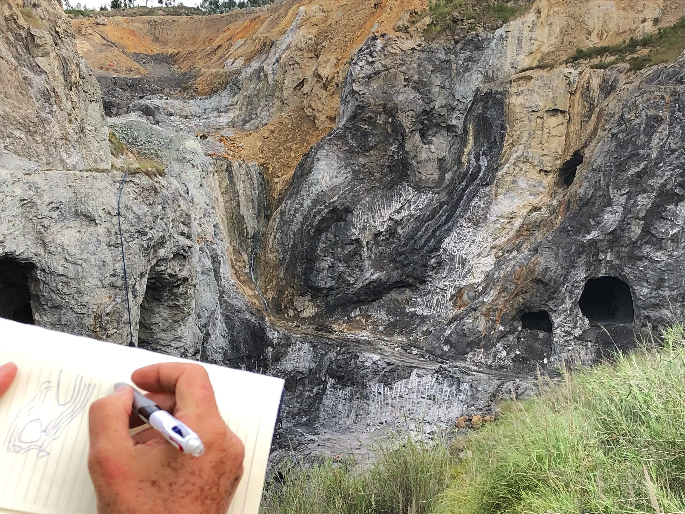
Here, Geo Logica contribution was to provide access and carry out detailed sampling of the units exposed on a rock face of an old quarry called Pedreira de Engenharia. At that time, this outcropping sequence part of the Upper Palaeozoic Cabrela Basin (western Ossa-Morena Zone) was under-sampled. The only study performed here was in 1972 with only the base of the quarry being sampled. Therefore our work was focus on providing rope access to the face for vertical selection, collection and catalog of rock samples and later transport via boat to the quarry lake shore.
Ultimately on the collected samples, after lab analysis, biostratigraphers found fossils (conodont specimens) tthat allowed to set stratigraphically the complete calciturbiditic sequence (carbonates) exposed here, recognising two zones that reconfirmed an early to middle Eifelian age (Devonian) of these rocks.
Related links: www.researchgate.net
Lusitanian BAsin Salt tectonics REvised (2017-2020)
-
The large outcropping salt diapirs or “les aires Diapiriques ou Aires Typhoniques” were firstly described in this basin by Choffat in the XIX century, particularly at Caldas da Rainha. Since then several authors have worked and proposed different mechanisms and explanations to the outcropping halokinetic sequences exposed in this part of Central Portugal.
After extensively reading and studying outcrops we decided that it was about time to review and update the knowledge about Lusitanian basin salt tectonics in the light of modern concepts and recent developments this peculiar geoscience subject.
Previous authors have suggested the main phase of salt diapirism in the Lusitanian Basin took place during the Alpine orogeny. However, we showed using seismic and onshore outcrop evidence that diapirism in the onshore started in the Early Jurassic soon after salt deposition with large N to NNE-trending salt walls developed along the main rift fault trend. The walls were surrounded by 1-2 km of Jurassic carbonates, which acted as a strong beam and inhibited the development of local rim synclines; instead salt was withdrawn evenly over wide areas into the diapirs leaving some relict salt pillows between diapirs showing onlap of the Jurassic carbonates on their flanks.
In addition we suggested that Late Cretaceous to Recent age (Alpine) compression produced squeezing of the salt and individual diapirs were developed, rising of the salt walls, and often piercing to the surface. This compression caused broad zones of bed upturn on a 1 km scale against the salt diapirs to form large potential hydrocarbon traps. The São Pedro de Moel diapir is a superb example of such a trap. The São Pedro de Moel diapir trapped a major oil field in upturned sandstones sealed against a sub-vertical salt wall.
We discovered and demonstrated that the Azeche bitumen mine and outcrops at Paredes de Vitoria (adjacent to São Pedro de Moel diapir), previously described as an oil seep, were in fact part of an exhumed oil field, probably filled to spill, and not merely a seep. This was demonstrated by the fact that oil-filled sandstones are completely saturated to at least 400 m away from the diapir contact.
While researching for this paper we also ended up discovering another natural hydrocarbon accumulation in Santa Cruz and also described for a new geological type of halokinetic unconformity which we suggest a new term for it – a ‘flap-onlap unconformity’.
Find more about the finding of this project in our GeoTraining Course entitle “Salt tectonics and Halokinetic sequences in the onshore Lusitanian basin”
Related links: www.researchgate.net
Geological Remote Sensing GRoup (GRSG) Anual Group MEeting Fieldtrip (2017)

-
The field trip counted with approximately 30 participants that looked into following thematics and its relation with geological remote sensing problematics:
From the Cretaceous Portuguese Bahamas to Central Atlantic opening: Observe Barremianreefs with rudists to the late Aptian Break-up Sequence.
Granites and related contact metamorphism at the Westernmost point of continental Europe.
Igneous intrusions and their tectonic effect on surrounding sedimentary basins.
Dinosaur footprints on lower Cretaceous carbonate protected shelf sequence.
Alpine Inversion tectonics: Fault-propagation folding affecting Upper Albian to Cenomanian marls.
Related links: www.grsg.org.uk